What is Compass Surveying
Compass surveying is recommended when
1.A large area to be surveyed.
2.The course of a river or coastline is to be surveyed.
3.The area is crowded with many details and triangulation is not possible.

Compass Surveying

Definition
In chain surveying, the area to be surveyed is divided into some triangles. This method is suitable for fairly level ground covering small areas. But triangulation is not possible when the area is large, undulating, and crowded with many details. In such an area, the method of compass surveying is adopted.
Read More: What Is the Chain Surveying
Read More: What Is Plane Table Survey
Purpose
i. Compass surveying is recommended when a large area is to be surveyed and triangulation is not possible.
ii. The principle of compass surveying is traversing.
iii. The direction of survey lines is fixed by angular measurements.
iv. The running of check lines is not necessary.
v. Angular measurement is involved, so it is not ad simple as chain surveying.
Fore Bearing(F.B)
The bearing of a line measured in the direction of the progress of the survey is known as the fore bearing of the line.
Back Bearing(BB)
The bearing of a line measured in the direction opposite of the survey is known as Back Bearing.
Reduce Bearing(R.B)
When the whole circle bearing (WCB) lien is converted to quadrant bearing is known as reducing bearing(RB)
This system measures the bearing clockwise or counterclockwise from the north or shouts towards the east or west. There are four quadrants denoted by NE, NW, SE, and SW. Its values line between 00 and 900.
Whole Circle Bearing(WCB)
The magnetic bearing of a line measured clockwise from the north pole towards the line. Its value like between 00- 3600.
Local Attraction
A magnetic needle indicates the north direction. But if the needle comes bear magnetic substances such as iron, steel structure, electric cables conveying current, etc. It is deflected from its true direction and does not show the actual north. This disturbing influence of magnetic substances is known as ‘local attraction’.
 |
| Compass Surveying |
Principle Of Compass Surveying
The principle of compass surveying is traversing, which involves a series of connected lines. The magnetic bearing of the lines is measured by a prismatic compass and the distance of the lines is measured by a prismatic compass and the distances of the lines are measured by the chain. Such a survey does not require the formation of a network of triangles.
Interior details are located by taking offsets from the main survey lines. Sometimes subsidiary lines may be taken for locating these details.
Compass surveying is recommended when
1. A large area to be surveyed.
2. The course of a river or coastline is to be surveyed.
3. The area is crowded with many details and triangulation is not possible.
Compass surveying is not recommended for areas where the local attraction is suspected due to the presence of magnetic substances like steel structures, iron-ore deposits, electric cables conveying current, and so on.
Traversing
Close traverse: When a series of connected lines form a closed circuit, the finishing point coincides with the starting points of a survey, known as a close traverse.
Open traverse: When a sequence of connected lines extends along a general direction and does not coincide with starting point is known as an open traverse.
Methods Of Traversing
Traverse surveying may be conducted by the following methods
- Chain traversing (by chain angle).
- Compass traversing (by free needle).
- Theodolite traversing(by fast needle).
- Plane table traversing(by plane table).
 |
| Compass Surveying |
1. Chain Traversing
Chain traversing is mainly conducted when it is not possible to adopt triangulation. In this method, the angles between adjacent sides are fixed by chain angles. The entry survey is conducted by chain and tape only and no angular measurements are taken. When it is impossible to form triangles, for example, chain traversing is conducted in a pond.
2. Compass Traversing
In this method, the fore and back bearings of the traverse legs are measured by a prismatic compass and the sides of the traverse by chain or tape. Then the observed bearings are verified and necessary corrections for local attraction are applied. In this method, a closing error may occur when the traverse is plotted. This error is adjusted graphically by using Bowditch’s rule.
3. Theodolite Traversing
In such traversing, the horizontal angles between the traverse legs are measured by a theodolite. The lengths of the legs are measured by a chain or by employing the stadia method. The magnetic bearing of the starting leg is measured by a theodolite. Then the magnetic bearings of the other sides are calculated. The independent coordinates of all the traverse stations are then found out. This method is very accurate.
4. Plane table traversing
In this method, a plane table is set at every traverse station in the clockwise or anticlockwise direction, and the circuit is finally closed. During traversing, the sides of the traverse are plotted according to any suitable scale. At the end of the work, any closing error which may occur is adjusted graphically.
Types Of Compasses
There are two types of compasses:
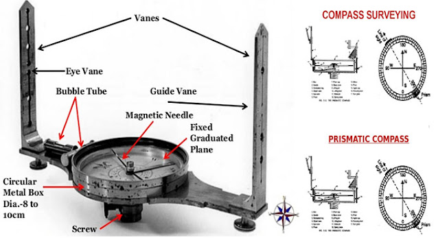
1. Prismatic Compass
In this compass, the readings are taken with the help of a prism. The following are the essential parts of this compass:
(a) Compass Box
The compass box is a circular metallic box of 8 to 10 cm in diameter. A pivot with a sharp point is provided at the center of the box.
(b) Magnetic Needle And Graduated Ring
The magnetic needle is made of a broad, magnetized iron bar. The bar is pointed at both ends. The magnetic needle is attached to a graduated aluminum ring.
The ring is graduated from 00-3600 clockwise, and the graduations begin from the shouting end of the needle.
(c) Sight Vane And Prism
The sight vane and the reflecting prism are fixed diametrically opposite to the box. The sight vane is hinged with a metal box and consists of horsehair at the center. The prism consists of a sighting slit at the center. The prism consists of sighting silt at the top and two small circular holes, one at the bottom of the prism and the other at the side of the observer’s eye.
(d) Dark Glasses
Two dark glasses are provided with the prism. The red glass is meant to light luminous objects at night, and the blue glass reduces the strain on the observer’s eye in bright daylight.
(e) Adjustable Mirror
A mirror is provided with the sight vane. The mirror can be lowered or raised, and can also be inclined. If any object is too low or too high concerning the line of sight, the mirror can be adjusted to observe it through reflection.
(f) Brake Pin
A brake pin is provided just at the base of the sight vane. If pressed gently, it stops the oscillations of the ring.
(g) Lifting pin
A lifting pin is provided just below the sight vane. When the sight vane is folded, it presses the lifting pin. The lifting pin then lifts the magnetic needle out of the pivot point to prevent damage to the pivot head.
(h) Glass Cover
A glass cover is provided on top of the box to protect the aluminum ring from dust.
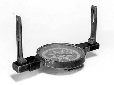
2. Surveyor’s Compass
The surveyor’s compass is similar to the prismatic compass except for the following points.
(a) There is no prism on it. Readings are taken with the naked eye.
(b) It consists of an eye-vane with a fine sight slit.
(c) The graduated aluminum ring is attached to the circular box. It is not fixed to the magnetic needle.
(d) The magnetic needle moves freely over the pivot. The needle shows the reading on the graduated ring.
(e) The ring is graduated from 00-900 in four quadrants. 00 is marked at the north and south, and 900 at east and west. The letters E(east) and W(west) are interchanged from their true positions. The figures are written the right way up.
(f) No mirror is attached to the object vane.
 |
| Surveying |
Equipment Required For Compass Survey
The following equipment is required for conducting a compass survey.
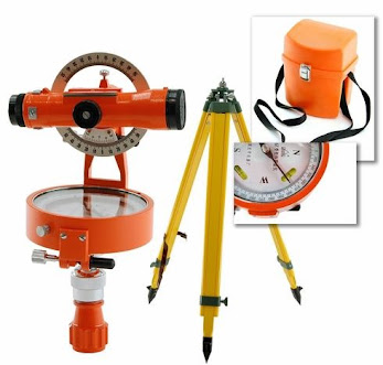
- Prismatic compass with stand = 1
- Metric chain(20m) =1
- Metallic tape(15m) =1
- Arrows = 10
- Ranging rods = 3
- Cross-staff or optical square = 1
- Plumb-bob = 1 set.
- Tri- square or wooden set square = 1
- Wooden pegs = 10
- Mallet or hammer = 1
- Field book =1
- Good pencil = 1
- Eraser = 1
- Knife = 1
Sources Of Error In A Compass
The following are the kinds of errors that may occur while taking readings with a compass:
1. Instrumental Errors
(a) The needle may not be perfectly straight and might not be balanced properly.
(b) The pivot point may be eccentric.
(c) The graduations of the ring may not be uniform.
(d) The ring may not rotate freely on account of the pivot point being broken because of careless handling.
(e) The sight vane may not be vertical.
2. Personal Errors
(a) The centering may not be done perfectly over the station.
(b) The graduated ring may not be leveled.
(c) The object might not be bisected properly.
(d) The readings may be taken or entered carelessly.
(e) The observer may be carrying magnetic substances.
3. Other Sources Of Error
(a) There may be local attraction due to the presence of magnetic substances near the station.
(b) The magnetic field could vary on account of some natural causes.
(c) The magnetic declination might very.


No comments
Thank You For Your Comment.