Plane Table Surveying
Plane Table Surveying
 |
| Plane Table |
Definition
Plane table surveying is mainly suitable for filling interior details when traversing is done by theodolite. Sometimes traversing by a plane table may also be done. But this survey is recommended for work where great accuracy is not required. As this instrument's fitting and fixing arrangement is not perfect, most accurate work cannot be expected.
Read More: Chain Surveying in Surveying
Principle
The principle of the plane table is parallelism, meaning that the rays drawn from stations to objects on the paper are parallel to the lines from the stations to the objects on the ground. The relative positions of the objects on the ground are represented by their plotted positions on the paper and lie on the respective rays. The table is always placed at each of the successive stations parallel to the position it occupied at the starting station. Plane tabling is a graphical method of surveying. Here, the fieldwork and plotting are done simultaneously and such survey does not involve the use of a field book.
Accessories Required In-Plane Table Surveying
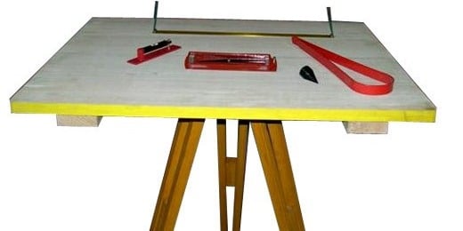
i. The plane table with tripod stand.
ii. Alidade.
iii. Though compass.
iv. The spirit level.
v. U-fork with a plumb bob.
vi. Metric chain(20m).
vii. Arrows.
viii. Ranging rods.
ix. Drawing sheet.
1. The Plane Table With Tripod Stand
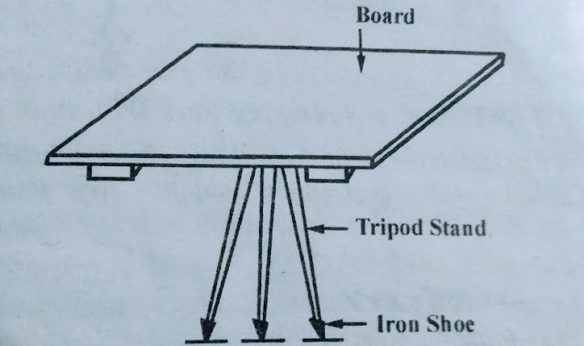
The plane table is a 750mm X 600mm size drawing board made of well-seasoned wood like teak, pine, etc. The top surface of the table is well leveled. The bottom surface consists of a threaded circular plate for fixing the table on the tripod stand by a wing nut.
2. The Alidade
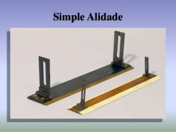
There are two types of alidade - plane alidade and telescopic alidade.
(a) Plane Alidade
The plane alidade consists of a metal or wooden ruler of length about 50cm. One of its edges is beveled and is known as the fiducial edge. It consists of two vanes at both ends which are hinged with the ruler. One is known as the object vane and carries horsehair, the other is called the sight vane and is provided with a narrow slit.
(b) Telescopic Alidade
The telescopic alidade consists of a telescope meant for inclined sight or sighting distant objects clearly. This alidade has no vanes at the ends but is provided with the fiducial edge.
(c) The function of the alidade is to sight objects.
The rays should be drawn along the fiducial edge.
3. The Compass
There are two kinds of compasses-
(a) The Trough Compass
(b) The Circular Box Compass.
(a) The Tough Compass
The trough compass is a rectangular box made of non-magnetic metal containing a magnetic needle pivoted at the center. This compass consists of a ‘0’ mark at both ends to located the N-S direction.
(b) The Circular Box Compass
It carries a pivoted magnetic needle at the center. The circular box is fitted on a square base plate. Sometimes two bubble tubes are fixed at right angles to each other on the base plate. The compass is meant for marking the north direction of the map.
4. The Spirit Level
The spirit level is a small metal tube containing a small bubble of spirit. The bubble is visible on the top along a graduated glass tube.
The spirit level is meant for leveling the plane table.
5. U-fork Or Plumbing Fork With Plumb Bob
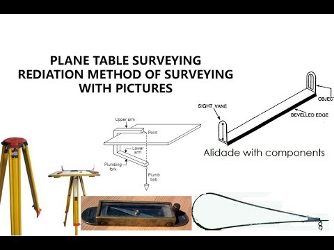
The U-fork is a mental strip bent in the shape of a ‘U’ having equal arm lengths. The top arm is pointed and the bottom arm carries a hook for suspending a plumb bob.
 |
| Alidade |
Methods Of Plane Tabling
The following are the four methods of plane tabling
1. Radiation.
2. Intersection.
3. Traversing.
4. Resection.
1. Radiation
This method is suitable for locating the objects from a single section. In this method, rays are drawn from the station to the objects, and the distances from the station to the objects are measured and plotted to any suitable scale along with the respective rays.
2. The Intersection Method
This method is suitable for locating inaccessible points by the intersection of the rays drawn from two instrument stations.
3. The Traversing Method
This method is suitable for connecting the traverse stations. This is similar to compass traversing or theodolite traversing. But here, fielding and plotting are done simultaneously with the help of the radiation and intersection methods.
4. The Resection Method
This method is suitable for establishing new stations at a place to locate missing details.
Sometimes, after the completion of plane table traversing, it may be noticed that an important object has not been located due to oversight.
The methods are based on
A) The Two-Points Problem.
B) The Three-Points Problem.
A) The Two-Points Problem
In this problem, two well-defined points whose positions have already been plotted on the plan are selected. Then, by perfectly bisecting these points, a new station is established at the required position.
B) The Three-Points Problem
In this problem, three well-defined points are selected whose positions have already been plotted on the map. Then, by perfectly bisecting these three well-defined points, a new station is established at the required position.
No auxiliary station is required to solve this problem. The table is directly placed at the required position.
The problem may be solved by three methods-
(a) The Graphical or Bessel Method.
(b) The Mechanical Method.
(c) The Trial & Error Method.
 |
| Plane Table Surveying |
Errors and Precautions
The following are the common errors in plane tabling-
A. Instrumental Errors
1. The surface of the table may not be perfectly level.
2. The fiducial edge of the alidade might not be straight.
3. The vanes may not be vertical.
4. The horsehair may be loose and inclined.
5. The table may be loosely joined with the tripod stand.
6. The needle of the trough compass may not be perfectly balanced. Also, it may not be able to move freely due to the sluggishness of the pivot point.
B. Personal Errors
1. The leveling of the table may not be perfect.
2. The table may not be centered properly.
3. The orientation of the table may not be proper.
4. The table might not be perfectly clamped.
5. The objects may not be bisected perfectly.
6. The alidade may not be correctly centered on the station point.
7. The rays might not be drawn accurately.
8. The alidade may not be centered on the same side of the station point throughout work.
C. Plotting Error
1. A good-quality pencil with a very fine pointed end may not have been used.
2. An incorrect scale may be used by mistake.
3. Errors may result from failure to observe the correct measurement from the scale.
4. Unnecessary hurry at the time of plotting may lead to plotting errors.
 |
| Plane Table Surveying |
Advantages & Disadvantages Of Plane Tabling
A. Advantages
1. It is the most rapid method of surveying.
2. There is no need for a field book as plotting is done along with the fieldwork. So, the problem of mistakes in booking field notes does not arise.
3. Plotted work can be compared with actual objects regardless of whether or not they are properly represented.
4. There is no possibility of overlooking any important object.
5. There is no possibility of overlooking any measurement as plotting is done in the field.
6. Irregular objects may be represented accurately.
7. It is suitable in magnetic areas.
8. The map can be prepared easily and does not require any great skill.
9. Errors in measurement and plotting can be detected by check lines.
10. Inaccessible points can be easily located by intersection.
B. Disadvantage
1. The plane table is not suitable for accurate work as the fitting arrangement is not perfect.
2. Plane table surveying is not suitable in wet climates, rainy seasons, foggy mornings, and windy weather.
3. The number of accessories required in such a survey is large, and they are likely to be lost.
4. The instrument is very heavy and difficult to carry.
5. The map cannot be re-plotted to a different scale as there is no field book.


No comments
Thank You For Your Comment.