Contouring In Surveying
Contouring Surveying
Definition
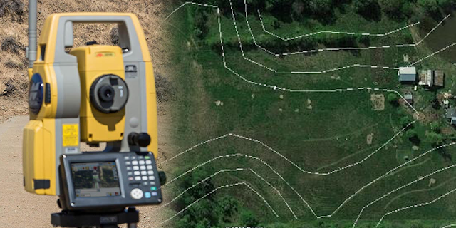
Contouring is basically, a leveling operation. The equipment is the same for leveling and contouring. The main objective of contouring is to determine the points on the ground having the same reduced level(RL). The contour lines join the points of the same elevation directly or by interpolation technique. It gives the topographical features of the ground, comparing different contour lines of different elevations for the closed areas. Based on the topographical features, calculations for engineering projects can be carried out.
There are different methods of drawing such as closed or open contour lines within a specific area.
Read More: What is Surveying. Definition & Clissifcation
Contour Line
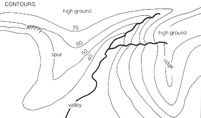
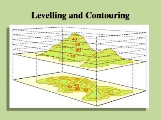
The line of intersection of a level surface with the ground surface is known as the contour line. It can also be defined as a line passing through points of equal reduced levels.
Contour Interval
The vertical distance between any two consecutive contours is known as contour interval. Suppose a map includes contour lines of 100m, 98m, 96m, and so on. The contour interval here is 2m. this interval depends upon
I. The nature of the ground.
II. The scale of the map.
III. The purpose of the survey.
Horizontal Equivalent
The horizontal distance between any two consecutive contours is known as the horizontal equivalent. It is not constant. It varies according to the steepness of the ground.
For steep slopes, the contour lines run close together, and for flatter slops, they are widely spaced.
The Object Of The Contouring Map
The general map of a country includes the locations of roads, railways, rivers, villages, towns, and so on. But the nature of the ground surface cannot be released from such a map. However, for all engineering projects involving roads, railways, and so on, a knowledge of the nature of the ground surface is required for locating suitable alignments and estimating the volume of earthwork. Therefore, the contour map is essential for all engineering projects. This is the way contour maps are prepared.
Characteristics Of Contouring Map
1. Every point on the same contour line has the same elevation.
2. A contour line always rejoins or closes upon itself to form a loop, although this may or may not occur within the map area.
3. Contouring lines never split.
4. Contouring lines never cross one another, however, if there is a steep cliff, they may appear to overlap because they are superimposed on one another.
5. Slopes rise or descend at right angles to any contouring line
i. Evenly spaced contours indicated a uniform slope.
ii. Closely spaced contours indicated a steep slope.
iii. Widely spaced contours indicated a gentle slope.
iv. Unevenly spaced contours indicate a variable or irregular slope.
6. Contouring usually encircles a hilltop, if the hill falls within the map area, the high point will be inside the innermost contour.
7. Contouring lines near the tops of hills or bottoms of valleys always occur in pairs having the same elevation on either side of the hill or valley.
8. Contouring always bend upstream where they cross-stream valleys.
9. If two adjacent contouring lines have the same elevation, a change in slope occurs between them.
Uses Of Contouring Map
1. The nature of the ground surface of a country can be understood by studying a contouring map.
2. To select the most economical and suitable site.
3. To find the capacity of a reservoir or the area of a catchment can be computed.
4. The intervisibility of different points can be established.
5. To locate a suitable route for a given gradient can be marked on the map.
6. To located the physical features of the ground.
7. Quantities of earthwork can be approximately computed.


No comments
Thank You For Your Comment.